Advanced Synthetic Aperture Radar (ASAR)
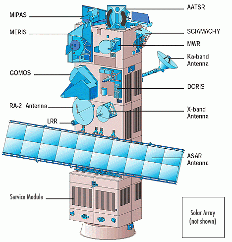
Source:http://www.naturalsciences.be Source: http://mtp.jpl.nasa.gov The ASAR instrument is operating at C-band and provides both continuity to the ERS-1 and ERS-2 mission SARs and next generation capabilities in terms of coverage, range of incidence angles, polarisation, and modes of operation. The resulting improvements in image and wave mode beam elevation steerage allow the selection of different swaths, providing a swath coverage more than 400km wide using ScanSAR techniques. ScanSAR is a Synthetic Aperture Radar (SAR) technique that combines large-area coverage and short revisit periods with a degraded spatial resolution compared to conventional SAR imaging modes. ASAR can provide a range of incidence angles ranging from 15° to 45° and can operate in alternating polarisation mode, providing two polarisation combinations (VV and HH, HH and HV, or VV and VH). The ASAR is onboard the EnviSat satellite, which was launched into a sun-synchronous orbit in March 2002. The exact repeat cycle for a specific scene and sensor configuration is 35 days. ASAR coverage for the SMAPEx study area is summarised in the table below. ASAR data can be downloaded from ESA.
Mission
ASAR
Sensor
Advanced Synthetic Aperture Radar (ASAR)
Spacecraft
Envisat
Launch date
1st, Mar. 2002
Design life
3 years with a goal of 5 years
Orbit
Sun-synchronous polar orbit (SSO): Nominal reference orbit of mean altitude 800km, 35 days repeat cycle, 10:00am mean local solar time (MLST) descending node, 98.55°. inclination. [envisat.esa.int]
Spacecraft operations control centre
ESA
Frequency (GHz)
5.331 (C-band)
Mode
Image mode
Polarisation
HH or VV
Incidence angle(°)
15~45
Swath (km)
Spatial resolution (m)
30
~30 150 1000 30 Temporal resolution
35 days repeat cycle
ASAR overpass time
The ASAR overpass times for the SMAPEx study area have been determined from the EOLi software, and are provided in the table below. Date and time are in UTC.
●=full ASAR coverage of airborne box; ○=partial ASAR coverage
●=concurrent; ●=non concurrent
Date (UTC)
ASAR overpass (UTC)
ASAR mode Polarisation Flight Type
05/07/2010 - - - ●Transect
06/07/2010
●12:53
Global Monitoring HH ●Regional
●Multi-angle07/07/2010
●23:36
Global Monitoring HH Target YB
08/07/2010
-
- - ●Regional
●Multi-angle09/07/2010
●12:59
Global Monitoring HH ●Target YA
10/07/2010
○23:42
Global Monitoring HH ●Regional
●Multi-angle